
You haven’t heard from me for a while.
I know and apologize. COVID made it super difficult with travel, quarantines, staging, supply line disruptions and the rest of it and I’ve been super busy with placing fishermen on Offshore Wind Survey vessels, providing provisions and logistical support for others, placing Captains, Mates, Cooks and AB’s on others. (High class problems for sure.)
Anyway, the title of this post is “Different Types of Surveys For Offshore Wind and What They Are Used For” and rather than taking the long road approach and write something up, I’m simple going to share with you a link to an excellent explanation.
My friend Julia Prince who works for Orsted, publishes a quarterly newsletter and her last one gives an excellent explanation of each type of Offshore Wind Survey.
Click The Link ==> https://a2f3e3.emailsp.com/frontend/nl_preview_window.aspx?idNL=259 or Read Below.
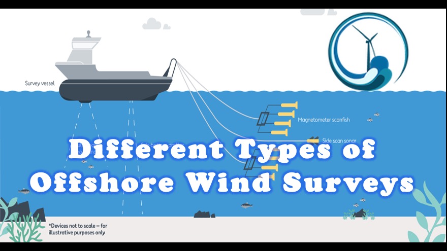
Different Types of Surveys
Geophysical operations

Engineering survey
Survey vessel tows delicate light weight equipment and operates hull mounted sensors between 3.5 and 5 knots in straight lines. Side scan and magnetometer fish are approximately 4 ft in length. Towed equipment is recovered and checked.

Reconnaissance survey
Survey vessel tows delicate light weight equipment and operates hull mounted sensors between 3 and 5.5 knots in straight lines. Streamer is approximately 250ft in length and 5-6inches in diameter.

Nearshore survey
Nearshore survey vessels tow delicate survey equipment and operate hull or pole mounted sensors in shallow waters generally less than 49 ft water depth. Vessel surveys at between 3 and 5 knots in straight lines. Side scan and magnetometer fish are 1.5m in length.
Geotechnical operations

Target inspections
Inspection vessel uses Dynamic Positioning (DP) to remain on station while working ROV is launched to inspect the seabed with onboard camera’s checking constantly in real time.

Geotechnical sampling
Geotechnical vessel uses Dynamic Positioning (DP) to maintain constant positioning on predetermined points while operating the sampling rig.
# # #
“At Offshore Wind Farm Support, we’ll continue to monitor for opportunities to assist Off Shore Wind with public relations, community out reach, education and public perception.”